
Climate Justice and the Paris Agreement
The second chapter of my dissertation has been published in Earth's Future! The paper is open access so please read and share. You can find the press release from UMass Amherst here and a blog breaking down the work here.
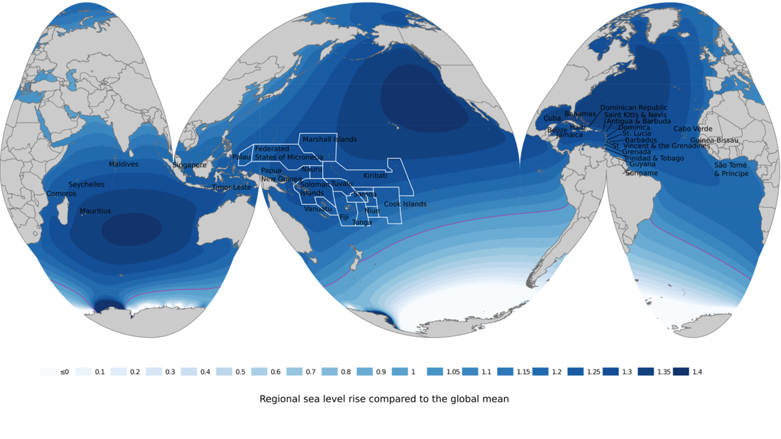
In the paper we assess climate justice in the context of sea level rise (SLR) & the Paris Agreement Long Term Temperature Goal (LTTG). Using a mixed methods approach grounded in critical physical geography we explore how the LTTG was developed, what the justice implications of it are when considering SLR, and how Antarctic projections interface with the LTTG and climate justice. In exploring these questions we center the advocacy of, and SLR implications for, the Alliance of Small Island States (AOSIS). AOSIS have consistently been the strongest advocates on the international stage working on issues of sea level rise for several decades. Using new SLR fingerprints we find that AOSIS members will be disproportionately impacted by Antarctic-sourced sea level rise, experiencing SLR from Antarctica at 11-34% above the global mean value (see figure below). This is a distributive injustice relative to their extremely low emissions contribution.
This work was inspired by the results from the first chapter of my PhD which showed that Antarctic melt could delay air temperature rise, while at the same time raising global sea levels. Exploring this issue became a key focus of my dissertation leading me to reshape my dissertation committee and scope to bring in social sciences training from human geography, political science, and critical theory. Thank you to Profs. Regine Spector, Eve Vogel, and Forrest Bowlick for teaching me so much during this time.
This map (Fig. 2a) shows the Antarctic sea level rise fingerprint for RCP4.5 (without cliff collapse). The purple line indicates global mean SLR. Mapping methods follow Gosling-Goldsmith, Ricker, and Kraak (2020) to highlight ocean states. Fingerprint data was provided from Natalya Gomez and Jeremy Roffman.
In addition to the published version of the paper above, an abbreviated version of this work can be found in my 2021 AGU poster which has a downloadable version and DOI here.
Climate impacts of Antarctic instability
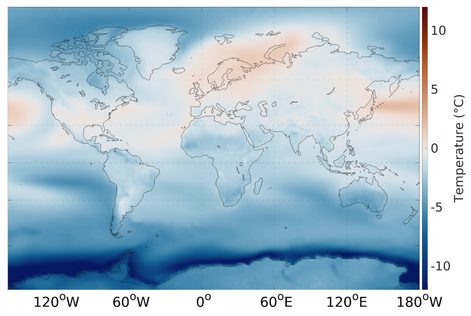
The initial work from my dissertation research was published in Science Advances. We used used the Community Earth System Model (CESM) 1.2 to assess the global climate response to Antarctic Ice Sheet melt provided by the Penn State University Ice Sheet model (PSU-3D) from the publication DeConto & Pollard 2016. Results showed a delay in the increase of projected global mean surface air temperature (GMST) rise under RCP4.5 and 8.5 through 2250, and an increase in 400 m water temperature, particularly in the Ross and Weddell Seas (Sadai et al., 2020). The simulated changes in climatology have implications for ice sheet evolution, and the Paris Agreement.

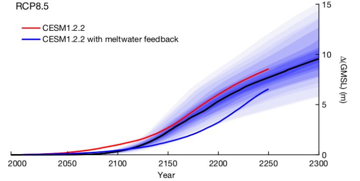
A preliminary assessment of the interaction between the competing feedbacks seen in this paper was published in Nature in 2021. In this work we used the meltwater-perturbed climatology from Sadai et al., 2020 to drive the PSU-3D ice sheet model. The net result of the two competing feedbacks- 1) the reduction in surface air temperature delaying surface melt and 2) the increase in 400 m ocean temperature accelerating basal melt was a delay in the pace of ice loss.
|
Image: Ensemble simulations of ice sheet response under RCP8.5 show a 5-10 m projected Antarctic contribution to sea level rise by 2300. Forcing for the ensemble used 400 m ocean temperatures provided by CCSM4 (the precursor to CESM1) and atmospheric forcing provided by an RCM. Alternative simulations show the ice sheet response to CESM1 ocean and atmosphere forcing in a control simulation (red) and meltwater perturbed simulation (blue). This image is from DeConto et al. 2021. |
Coupling Ice Sheet Models and Climate Models
Seeking to advance the work described above on Antarctica's impact on global climate I spent the past few years developing a method to couple the Community Earth System Model (CESM) 1.2 (Hurrel, 2013) and the Penn State University Ice Sheet model (PSU-3D) (Pollard & DeConto, 2012; Pollard & DeConto, 2015). CESM contains coupled ocean, atmosphere, sea ice, and land models. PSU-3D is a dynamic-thermodynamic ice sheet model with hybrid ice physics and a parameterization at the grounding line (Pollard and DeConto, 2012; Schoof, 2007).
After working to create a version of the ice sheet model which is able to closely simulate the real world changes in Antarctica over the observational period from 2005-2020 I have completed a simulation for RCP8.5 extending past 2200. Coupling the two models allows for a better view of how ice sheet mass loss impact climatology and in turn how meltwater-perturbed climatology impacts ice sheet evolution. Initial results can be found at this poster, and further results from the first completed coupled simulation will be shown at AGU 2022 in C43B-03.
After working to create a version of the ice sheet model which is able to closely simulate the real world changes in Antarctica over the observational period from 2005-2020 I have completed a simulation for RCP8.5 extending past 2200. Coupling the two models allows for a better view of how ice sheet mass loss impact climatology and in turn how meltwater-perturbed climatology impacts ice sheet evolution. Initial results can be found at this poster, and further results from the first completed coupled simulation will be shown at AGU 2022 in C43B-03.
Multispecies Climate Justice and Sea Level Rise
Climate justice is not solely limited to human systems, rather a more expansive and inclusive view provided by multispecies climate justice takes into consideration the interconnected human and nonhuman systems that shape global ecologies (Tschakert et al., 2021). I first began exploring this topic for a talk given at the Animals x Climate x Health speaker series (the video can be found on the outreach page). At the NESTVAL conference in 2021 I gave a more condensed talk on this subject focusing in on multispecies climate justice and sea level rise. Determining the impacts that sea level rise has on biodiversity conservation, ecosystem functioning, and the wellbeing of individual humans and nonhuman animals is an important avenue to assess as we seek to confront the climate crisis in a way that centers climate justice.
|
Drawing from political ecology, animal geographies, and biological and ecological sciences literature I have begun developing a preliminary framework for considerations of multispecies climate justice as it relates to sea level rise drivers, impacts, and adaptations. Thank you to the Culture and Animals Foundation for financially supporting my work on this project!
In 2022 Stephanie Rutherford and I convened a series of 5 sessions on Multispecies Climate Justice at the American Association of Geographers conference. Following from this we have joined with Sylvia Cifuentes to bring the work from those sessions, and related research, into a journal special issue (updates forthcoming). |
|
The text below is what I wrote when I first began my PhD. I am leaving it up as it is still relevant.
What happens in Antarctica doesn't stay in Antarctica.
My research focuses on using global climate modeling to determine how the climate system as a whole might respond to changes in the Antarctic Ice Sheet (AIS). Antarctica is currently undergoing rapid changes. Observational evidence indicates that the West Antarctic Ice Sheet (WAIS) is losing mass at an accelerating rate.[1][2][3] This is important because the WAIS is estimated to contain an ice volume equivalent to over 3 m (~10 ft) sea level rise.[4] Modeling projections show that the Antarctic ice sheet as a whole has the potential to contribute up to 1 m (~3.3 ft) of sea level rise by the end of this century.[5] Sea level rise is only one aspect of how changes in Antarctica might impact our world. There are many more ways in which changes in the AIS can impact our planet and these are what I am researching.
What is so special about Antarctica?
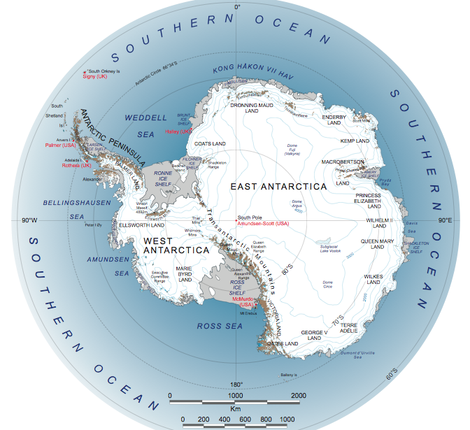
Antarctica is split into two basic sections- the East Antarctic Ice Sheet and the West Antarctic Ice Sheet, which are separated by the Transantarctic Mountains. Each side has a distinctive layout of bedrock under the ice and the differences between the two sides lead to there being substantially different stabilities between the two.
What happens in Antarctica doesn't stay in Antarctica.
My research focuses on using global climate modeling to determine how the climate system as a whole might respond to changes in the Antarctic Ice Sheet (AIS). Antarctica is currently undergoing rapid changes. Observational evidence indicates that the West Antarctic Ice Sheet (WAIS) is losing mass at an accelerating rate.[1][2][3] This is important because the WAIS is estimated to contain an ice volume equivalent to over 3 m (~10 ft) sea level rise.[4] Modeling projections show that the Antarctic ice sheet as a whole has the potential to contribute up to 1 m (~3.3 ft) of sea level rise by the end of this century.[5] Sea level rise is only one aspect of how changes in Antarctica might impact our world. There are many more ways in which changes in the AIS can impact our planet and these are what I am researching.
What is so special about Antarctica?
Antarctica is split into two basic sections- the East Antarctic Ice Sheet and the West Antarctic Ice Sheet, which are separated by the Transantarctic Mountains. Each side has a distinctive layout of bedrock under the ice and the differences between the two sides lead to there being substantially different stabilities between the two.
|
On the eastern side the configuration of the bedrock underlaying the ice sheet is similar to that of Greenland where the bedrock slopes down towards the ocean. The western side on the other hand is marine based with floating ice shelves surrounding the grounded portion of the sheet which sits on bedrock that actually slopes down toward the interior of the continent instead of down towards the ocean. This means that a large portion of the grounded ice is actually below sea level underneath all of the ice above. The ice there is held in place by the buttressing effects of the floating ice shelves, which are attached to the bedrock at what is known as the grounding line.
|
Credit- NASA
|
As the climate is changing due to human induced greenhouse gas emissions, the atmosphere and ocean are both heating up. The warming ocean waters flow underneath the floating ice shelves and melt away the ice at the base of the sheet near the grounding line. This causes the grounding line to move back towards the interior of the continent as the warm ocean water eats away at it from below which can lead to a process known as Marine Ice Sheet Instability (MISI). When the buttressing effects of the ice shelves are removed and the grounding line retreats the grounded ice begins to slide towards the ocean at which point MISI can become a run away process in which the ice sheet over the continental interior of the WAIS can catastrophically collapse.[4][5][7] Observational evidence suggests that MISI has already begun in West Antarctica.[3]
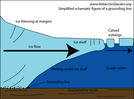
A simplified side view of the grounding line. Credit- AntarcticGlaciers.org
That sounds bad. What are some of the possible impacts of this?
As the freshwater that was formerly locked up in the ice sheet enters the ocean the sea level will rise leading to displacement of people in coastal communities, damage to infrastructure, and impacts to coastal ecosystems. This is likely the most well known effects of AIS melt, however there will likely be other impacts to the climate system. Changes in ocean circulation patterns alter this transport and this has many implications for the global climate which can include changes in temperature at different regions, shifts in precipitation patterns, changes in wind patterns, and more. The world's oceans are vast but interconnected. Water moves around the planet via currents and these are responsible for transporting heat, salt, and nutrients. The way the water moves is driven by variations in the temperature and salt content which together determine the water's density. There are several spots on the planet where variations in water density cause the water to sink to depth. These regions are called deep water formation areas and they are the driving force of the global currents. The deep water formation areas are located in the North Atlantic and at locations off the coast of Antarctica. If freshwater gets added to these regions it alters the density of the surface water which inhibits deep water formation and can disrupt the global current system affecting heat transport and climate. In Antarctica this primarily happens due to warm water melting the ice from below and from iceberg calving.[6] You could say that what happens in Antarctica doesn't stay in Antarctica- it has the potential to impact all of us all over the planet.
As the freshwater that was formerly locked up in the ice sheet enters the ocean the sea level will rise leading to displacement of people in coastal communities, damage to infrastructure, and impacts to coastal ecosystems. This is likely the most well known effects of AIS melt, however there will likely be other impacts to the climate system. Changes in ocean circulation patterns alter this transport and this has many implications for the global climate which can include changes in temperature at different regions, shifts in precipitation patterns, changes in wind patterns, and more. The world's oceans are vast but interconnected. Water moves around the planet via currents and these are responsible for transporting heat, salt, and nutrients. The way the water moves is driven by variations in the temperature and salt content which together determine the water's density. There are several spots on the planet where variations in water density cause the water to sink to depth. These regions are called deep water formation areas and they are the driving force of the global currents. The deep water formation areas are located in the North Atlantic and at locations off the coast of Antarctica. If freshwater gets added to these regions it alters the density of the surface water which inhibits deep water formation and can disrupt the global current system affecting heat transport and climate. In Antarctica this primarily happens due to warm water melting the ice from below and from iceberg calving.[6] You could say that what happens in Antarctica doesn't stay in Antarctica- it has the potential to impact all of us all over the planet.
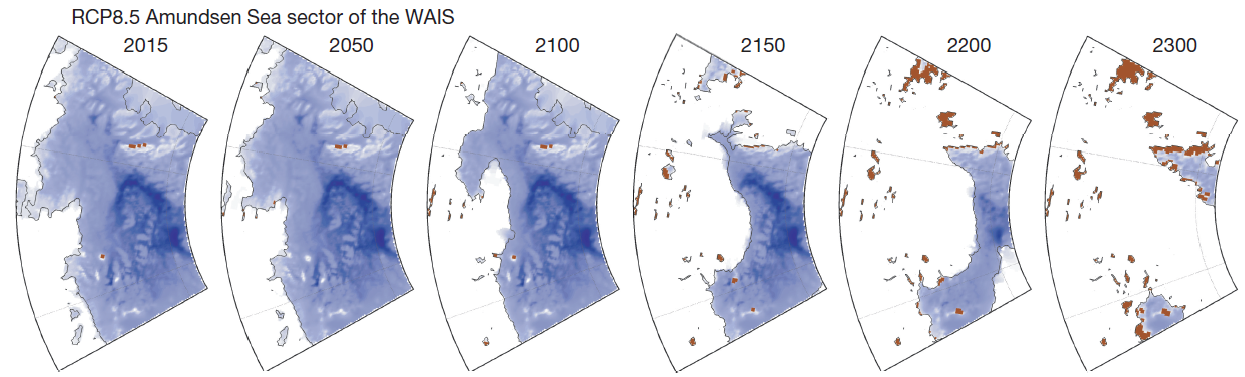
This panel shows the progression of ice mass loss for the Amundsen Sea sector of the WAIS in the DeConto/Pollard model under RCP 8.5. Credit: DeConto/Pollard 2016.
|
This is clearly an important area of study. How are you going to research it?
To project what may happen in the future we need state of the art climate models which are able to simulate physical processes of the ocean, atmosphere, and ice. I am using the Community Earth System Model (CESM), a high resolution fully coupled ocean-atmosphere model which allows for climate simulations that take into account many complicated and interconnected processes of the land, ocean, atmosphere, and cryosphere. |
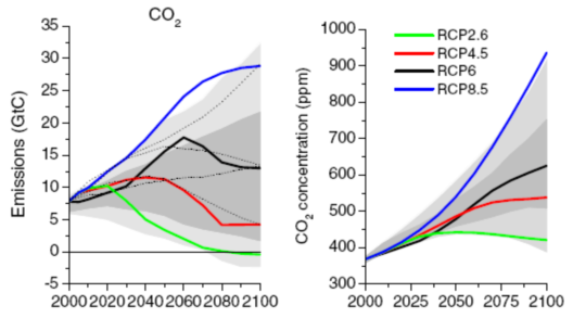
The emissions in gigatons of CO2 over time under each RCP scenario (left) and the resulting atmospheric CO2 concentrations (right). Credit: IPCC.
|
My experiments will take into account two main things. One of which are the Representative Concentration Pathways (RCPs) created by the Intergovernmental Panel on Climate Change (IPCC). The IPCC RCP scenarios were created by a huge international collaboration of scientists and help describe how climate forcing can differ based on anthropogenic (human caused) greenhouse gas emissions. Since these scenarios are standardized internationally they help scientists compare their results. The second is freshwater discharge where the freshwater is the result of another simulation done by Rob DeConto (UMass Amherst) and Dave Pollard (Penn State). They used a regional ice sheet-ice shelf model for Antarctica to look at how the AIS may evolve under greenhouse gas forcing of the RCP scenarios. Their results give us a very high resolution look at how the ice sheet may change and provide data on the amounts of freshwater released as ice calving, sub-ice sheet melting, and more. Since their regional model is state of the art and very high resolution it gives a much more intricate picture of changes in the ice sheet. I can then feed in their results to the global climate model, along with the RCP scenarios, and get a better picture of how greenhouse gas induced radiative forcing changes and ice mass loss in the WAIS could impact changes in ocean circulation, global temperatures, wind patterns, and more. Preliminary results from my experiments will be forthcoming.
References:
[1] Jeong, S., Howart, I., Bassis, J. Accelerated ice shelf rifting and retreat at Pine Island Glacier, West Antarctica. Geophysical Research Letters, November 2016.
[2] Khazendar, A., et. al. Rapid submarine ice melting in the grounding zones of ice shelves in West Antarctica. Nature Communications, October 2016.
[3] Rignot, E. et. al. Widespread, rapid grounding line retreat of Pine Island, Thwaites, Smith, and Kohler glaciers, West Antarctica, from 1992 to 2011. Geophysical Research Letters, May 2014.
[4] Feldman, J. and Levermann, A. Collapse of the West Antarctic Ice Sheet after local destabilization of the Amundsen Basin. PNAS, October 2015.
[5] DeConto, R. and Pollard, D. Contribution of Antarctica to past and future sea-level rise. Nature, Vol. 531, March 2016.
[6] Depoorter, M. et. al. Calving fluxes and basal melt rates of Antarctic ice shelves. Nature, Vol. 502, October 2013.
[7] Joughlin, I., et. al. Ice-sheet Response to Oceanic Forcing. Science, Vol. 338, November 2012.